Electronic intelligence
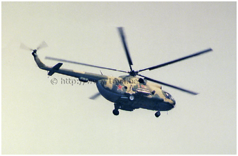
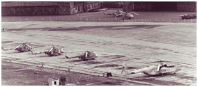
 A handful of helicopters of the 239.OGVP from Oranienburg (1), a unit which
was directly subordinate to 16.VA Headquarters, had been made available for the
Ministerium für Staatssicherheit (Ministry for State Security, better known as Stasi) for electronic and
photographic intelligence missions code named RELAIS II, between 1983 and 1989.
These helicopters were carrying multiband receivers, of which the antennas were located on the right side of the forward
fuselage. Whereas the crew was Soviet, the personnel in the cargo hold was East German. The latter was composed of an
interpreter, a photographer and two radio operators.
Spy flights took off from Oranienburg, a base situated a few kilometres north of the French occupation zone, and followed
the West-Berlin borders in a clockwise direction. Data about the Allied communications systems were collected and various
military communication and listening equiments were photographed as well from the rear cabin window.
A handful of helicopters of the 239.OGVP from Oranienburg (1), a unit which
was directly subordinate to 16.VA Headquarters, had been made available for the
Ministerium für Staatssicherheit (Ministry for State Security, better known as Stasi) for electronic and
photographic intelligence missions code named RELAIS II, between 1983 and 1989.
These helicopters were carrying multiband receivers, of which the antennas were located on the right side of the forward
fuselage. Whereas the crew was Soviet, the personnel in the cargo hold was East German. The latter was composed of an
interpreter, a photographer and two radio operators.
Spy flights took off from Oranienburg, a base situated a few kilometres north of the French occupation zone, and followed
the West-Berlin borders in a clockwise direction. Data about the Allied communications systems were collected and various
military communication and listening equiments were photographed as well from the rear cabin window.
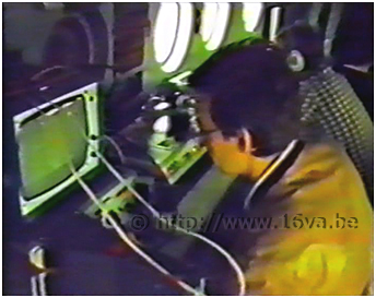 Les consoles des opérateurs est-allemands à bord d'un Mi-8 du 239.OGVP lors d'une mission "RELAIS" le long des frontières de
Berlin-Ouest. © V.Liebscher.
Les consoles des opérateurs est-allemands à bord d'un Mi-8 du 239.OGVP lors d'une mission "RELAIS" le long des frontières de
Berlin-Ouest. © V.Liebscher.
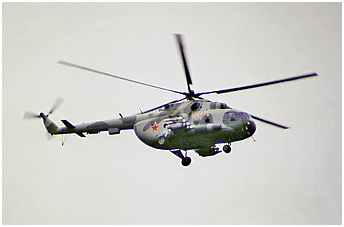
East German operators aboard a Mi-8 of the 239.OGVP during a "RELAIS"
mission along the West-Berlin borders. © V.Liebscher.
 A video camera mounted on a stabilised platform, was sometimes used to identify more easily the places where photographs had been taken.
It was also a good means to estimate the position of the antennas observed during the flight.
A typical flight lasted 100 minutes at an altitude of 100 meters at a flying speed of 110 km/h on average.
When necessary, the helicopter could climb to 200-300 meters and fly at a lower speed to photograph some targets.
Some electronic intelligence gathering could require a climb up to 1600 meters.
The informations collected by the East German agents were of course shared with their Soviet counterparts, the KGB
(2).
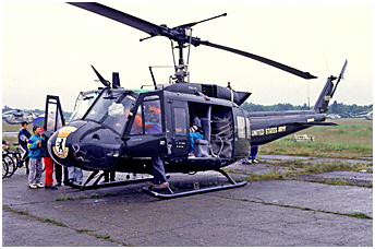
The Mi-8 were sometimes "escorted" by Allied aircraft or helicopters based at Tempelhof (Bell UH-1H and possibly
Pilatus UV-20A - Berlin Avn. Det.) or at Gatow (Gazelle AH.1 - 7 Flight AAC, DHC Chipmunk T.10 - RAF Gatow Station Flight).
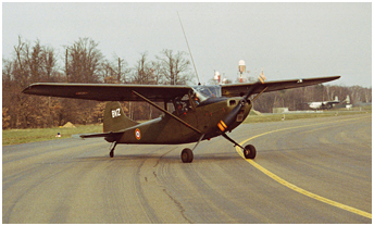
We ignore if Alouette III, Cessna L19E (DETALAT) or the MH-1521M Broussard and later the single DHC-6 Twin Otter
(Armée de l'Air) of the French forces based at Tegel made such encounters.
A video camera mounted on a stabilised platform, was sometimes used to identify more easily the places where photographs had been taken.
It was also a good means to estimate the position of the antennas observed during the flight.
A typical flight lasted 100 minutes at an altitude of 100 meters at a flying speed of 110 km/h on average.
When necessary, the helicopter could climb to 200-300 meters and fly at a lower speed to photograph some targets.
Some electronic intelligence gathering could require a climb up to 1600 meters.
The informations collected by the East German agents were of course shared with their Soviet counterparts, the KGB
(2).
The Mi-8 were sometimes "escorted" by Allied aircraft or helicopters based at Tempelhof (Bell UH-1H and possibly
Pilatus UV-20A - Berlin Avn. Det.) or at Gatow (Gazelle AH.1 - 7 Flight AAC, DHC Chipmunk T.10 - RAF Gatow Station Flight).
We ignore if Alouette III, Cessna L19E (DETALAT) or the MH-1521M Broussard and later the single DHC-6 Twin Otter
(Armée de l'Air) of the French forces based at Tegel made such encounters.
 |
 |
Spy games
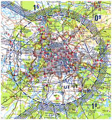
 The Berlin Control Zone (BCZ) was established by the four occupying powers after the end of WWII. The BCZ was a transit area
for the aircraft flying throught the three air corridors (north-A, center-B and south-C) linking West-Berlin to the
so-called free world. Any American, British, French,
or Soviet aircraft could theorically fly through that area. West-Berlin was however off limits for the Soviet
aircraft and helicopters (at least under 3000 meters) (3)
because it was considered as a sovereign entity like the FRG.
That is the reason why the ELINT/PHOTINT Mi-8
were flying along its borders rather than directly over the different targets. In case of an emergency landing
on the wrong side of the border and in order to try to
avoid any diplomatic incident, the East German agents did not carry any official documents with them and they had been
briefed to remain aboard the helicopter. Notes taken during the flight, were written on water
dissolvable paper and a water container was carried onboard for that purpose. However, documents like flight plans couldn't
be destroyed as well as the electronic equipement and consequently, it would have been difficult to deny the real nature of the
mission.
The Berlin Control Zone (BCZ) was established by the four occupying powers after the end of WWII. The BCZ was a transit area
for the aircraft flying throught the three air corridors (north-A, center-B and south-C) linking West-Berlin to the
so-called free world. Any American, British, French,
or Soviet aircraft could theorically fly through that area. West-Berlin was however off limits for the Soviet
aircraft and helicopters (at least under 3000 meters) (3)
because it was considered as a sovereign entity like the FRG.
That is the reason why the ELINT/PHOTINT Mi-8
were flying along its borders rather than directly over the different targets. In case of an emergency landing
on the wrong side of the border and in order to try to
avoid any diplomatic incident, the East German agents did not carry any official documents with them and they had been
briefed to remain aboard the helicopter. Notes taken during the flight, were written on water
dissolvable paper and a water container was carried onboard for that purpose. However, documents like flight plans couldn't
be destroyed as well as the electronic equipement and consequently, it would have been difficult to deny the real nature of the
mission.
Update: the part of this page relating the Stasi operations is now the subject of a dedicated and more detailed page
> here.
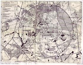
 The Berlin Control Zone was a circular area with a radius of 20 miles and a ceiling of 3000 meters. Its center was situated
at Kleistpark, north of Tempelhof, in the former building of the Allied Control Authorities. As mentioned earlier, the BCZ
was connected to the three air corridors of West-Berlin.
Soviet and East German aircraft could cross freely these corridors. The Allied aircraft could fly through them and inside the
BCZ itself. The helicopters however couldn't fly outside the limits of West-Berlin itself.
The Berlin Control Zone was a circular area with a radius of 20 miles and a ceiling of 3000 meters. Its center was situated
at Kleistpark, north of Tempelhof, in the former building of the Allied Control Authorities. As mentioned earlier, the BCZ
was connected to the three air corridors of West-Berlin.
Soviet and East German aircraft could cross freely these corridors. The Allied aircraft could fly through them and inside the
BCZ itself. The helicopters however couldn't fly outside the limits of West-Berlin itself.
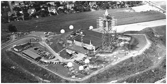
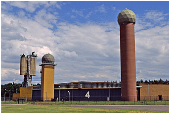
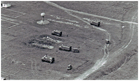
Quite a lot of East German and Soviet military installations were located inside the BCZ, which covered East-Berlin and its
surroundings - including Oranienburg and Werneuchen airbases - and the three air corridors.
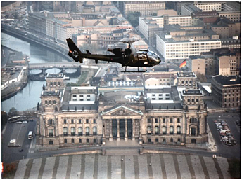
 Largely unknown during the Cold War and almost unbelievable, the Allied aircraft based in Berlin flying with agents of the Military Liaison Missions to the
Soviet Supreme High Command in Germany aboard, could therefore overfly and photograph these targets. They were sometimes disturbed
during their "work" by lighting rockets or fighters crossing their path. Moreover, discreet Allied electronic and photographic intelligence aircraft could
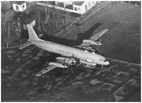
fly through the Berlin air corridors. The French flew regularly with Nord N2501 Gabriel - replaced by two
C160 Gabriel in 1989 - of the EE.54 based at Metz along the German and the Czechoslovak borders and inside the Berlin corridors.
They landed at Berlin-Tegel before heading back home through a different corridor. "Baltic" missions implied
a fly through the north corridor after the take off from Tegel in order to join the Baltic Sea.
They flew up to the Polish border before flying back home to Metz via a stop over at Tegel. They were sometimes interecepted by Soviet or Swedish fighters above
the Baltic Sea.
Largely unknown during the Cold War and almost unbelievable, the Allied aircraft based in Berlin flying with agents of the Military Liaison Missions to the
Soviet Supreme High Command in Germany aboard, could therefore overfly and photograph these targets. They were sometimes disturbed
during their "work" by lighting rockets or fighters crossing their path. Moreover, discreet Allied electronic and photographic intelligence aircraft could
fly through the Berlin air corridors. The French flew regularly with Nord N2501 Gabriel - replaced by two
C160 Gabriel in 1989 - of the EE.54 based at Metz along the German and the Czechoslovak borders and inside the Berlin corridors.
They landed at Berlin-Tegel before heading back home through a different corridor. "Baltic" missions implied
a fly through the north corridor after the take off from Tegel in order to join the Baltic Sea.
They flew up to the Polish border before flying back home to Metz via a stop over at Tegel. They were sometimes interecepted by Soviet or Swedish fighters above
the Baltic Sea.
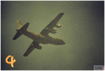 The Americans were flying specially equipped C-130E of the 7405.OS from Rhein-Main during the
eighties (radio call signs "Ask" and "Herky").
Beside the intelligence flights inside the air corridors themselves, they were the only one to venture above the BCZ with such aircraft.
According to ATC controllers, they even overflew the international civil airport of Berlin-Schönefeld and its trafic at 1500 feet. Moreover,
these flights had priority over the western civilian trafic.
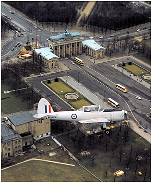
The British flew photo reconnaissance missions inside the corridors and above the BCZ with venerable Percival Pembrokes.
If Military Liaison Missions were disbanded in
1990-91, the collection of informations about the new Russian army continued through by other services in Germany.
Flying rules changed also after the German unification. The Allied aircraft could now fly through the BCZ and inside the area
located between the north and the south Berlin air corridors, whereas the helicopter flights were authorized inside the whole
area. However, the new official limits seemed much harder to respect by the Allied pilots who made quite a lot
of "navigational errors" and overflew off-limits military installations! However, the Russians did not seem to complain but it is true that the die was cast.
In fact, the real new limit was the aircraft and helicopter range:
they were not allowed to land on a former East-German base to refuel.
The Americans were flying specially equipped C-130E of the 7405.OS from Rhein-Main during the
eighties (radio call signs "Ask" and "Herky").
Beside the intelligence flights inside the air corridors themselves, they were the only one to venture above the BCZ with such aircraft.
According to ATC controllers, they even overflew the international civil airport of Berlin-Schönefeld and its trafic at 1500 feet. Moreover,
these flights had priority over the western civilian trafic.
The British flew photo reconnaissance missions inside the corridors and above the BCZ with venerable Percival Pembrokes.
If Military Liaison Missions were disbanded in
1990-91, the collection of informations about the new Russian army continued through by other services in Germany.
Flying rules changed also after the German unification. The Allied aircraft could now fly through the BCZ and inside the area
located between the north and the south Berlin air corridors, whereas the helicopter flights were authorized inside the whole
area. However, the new official limits seemed much harder to respect by the Allied pilots who made quite a lot
of "navigational errors" and overflew off-limits military installations! However, the Russians did not seem to complain but it is true that the die was cast.
In fact, the real new limit was the aircraft and helicopter range:
they were not allowed to land on a former East-German base to refuel.
 |
 |
 |
 > An analyse of the picture at right can be consulted here
> The Berlin Control Zone > Link
> The Berlin for Lunch Bunch homepage > Link
> Status of aerial reconnaissance in 1960 > Link
- Most of the information about the Mi-8 ELINT missions over Berlin come from the book of Volker Liebscher "RELAIS".
See > Multimedia.
- With special thanks to Eric Cartigny and Claude Pico for the detailed informations about the BCZ.
- Look at the BCZ and the Berlin air corridors on Google Earth: download the file entitled
"Luftraum Berlin und DDR 198x".
Choose carefully your options if you don't want to be overwhelmed with information.
notes
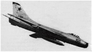 Un Su-7 au-dessus de Berlin-Ouest le 7 avril 1965. © Flight.
A Su-7 over West-Berlin on 7 April 1965. © Flight.
(1)
Known numbers:
Mi-8T '16'
Mi-8MT '34' c/n 93350 or 94350, '40' c/n 93361, '49' c/n 93344
Mi-8MTV-2 '05' c/n 94446
(2)
Komitet Gossudarstvennoï Bezopasnosti, Committee for State Security.
(3)
- On April 7, 1965, the German Parliament (Bundestag) held its meeting in the West-Berlin
Congress Hall despite protests from Soviet and East German authorities. Among other
disturbance actions, Soviet fighters overflew West-Berlin at low level during the whole day
> Link
& video to download > Link.
- During the Summer of 1981, some Mi-8 of the 239.OGVP flew across the glide path to
Berlin-Tegel in order to deny the landing of a LOT (Polish airlines) An-24 escaping to the
West. The latter finally landed at Tempelhof.
- Soviet aircraft and helicopters operating from the airfields situated inside the BCZ
(Oranienburg and Werneuchen) banked after take off to exit the zone. The Berlin-Frohnau sector was regulartly
overflown by MiG-25 taking off
from Werneuchen, probably above the BCZ ceiling.
| Plan du site - Sitemap |